Known as the silver king of the ocean due to its mirror-like scales, size, and prehistoric nature, the Atlantic tarpon (Megalops Atlanticus) can be found in warm parts of the Atlantic (the U.S. to Africa), the Caribbean Sea and the Gulf of Mexico.
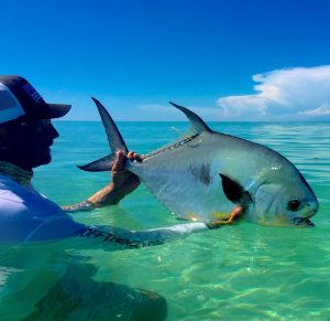
Permit. Photo: Jake Brownscombe
The silvery-gray permit (Trachinotus falcatus) is a popular game fish characterized by a short, compressed, and angular, deep body. Like tarpon, it can also be found in tidal flats, as well as near-shore reefs and wrecks along the Atlantic coast.
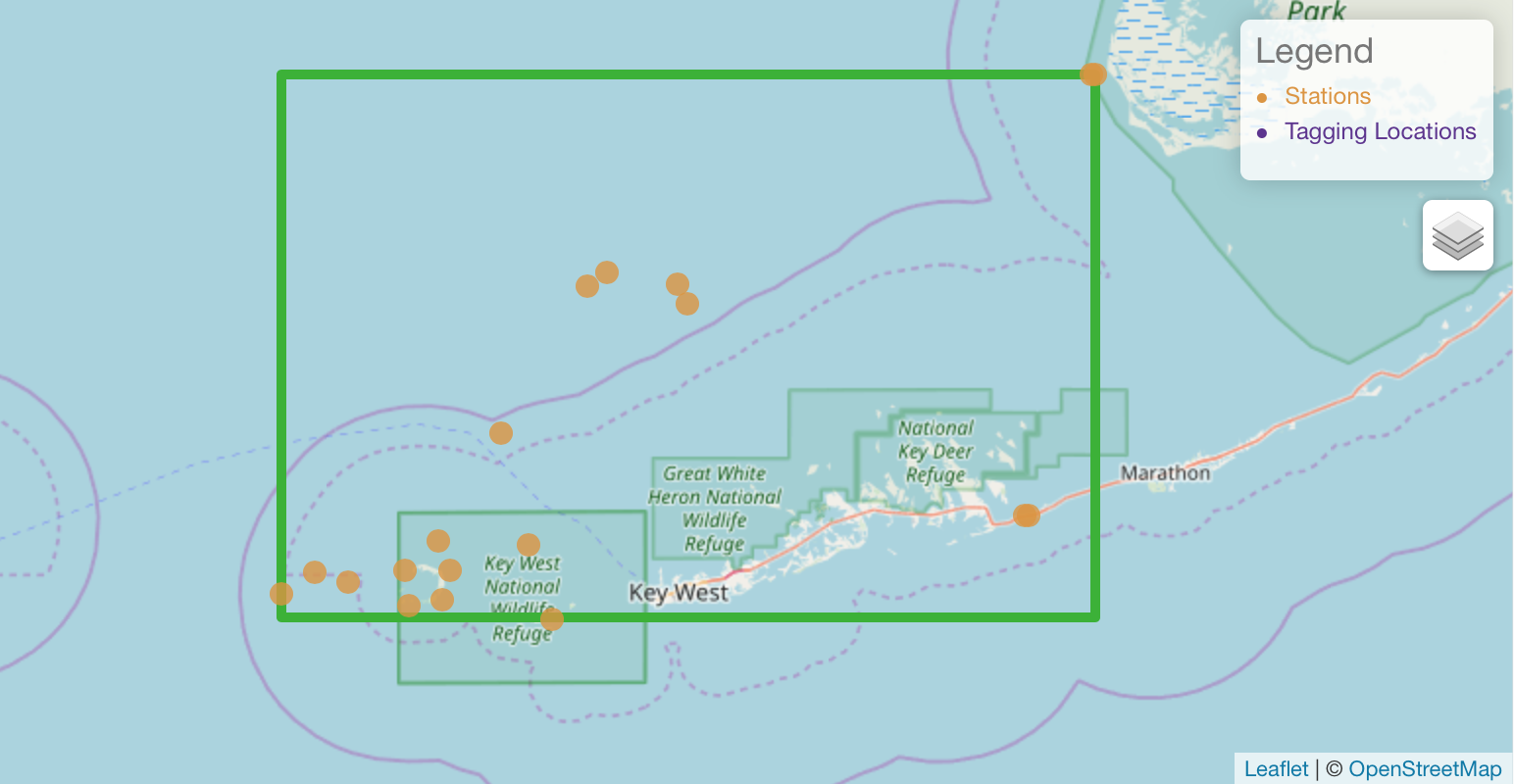
The Spatial Ecology of Permit and Atlantic Tarpon project in the Florida Keys, U.S., which is headed by Bonefish and Tarpon Trust (BTT, also in Florida), realized there was a lack of knowledge on the movement patterns of these species. Collaborators on the project included Carleton University, Dalhousie University (Canada), the University of Massachusetts Amherst, and the Florida Fish and Wildlife Conservation Commission (U.S.).
Why track permit and tarpon?
Permit and tarpon support highly productive recreational fisheries that generate major social and economic value. Both species are highly migratory and form important ecological connections between geographic regions and habitats. They’re also key members of the food web, distributing nutrients amongst nearshore habitats and serve as prey for top predators.
“The movement patterns of these species is essential information for developing effective habitat protection and fishing regulations to ensure their conservation,” said Dr. Jacob Brownscombe, Carleton University, Canada.
The tracking projects have already been successful in generating a positive conservation impact for permit, which are especially vulnerable to capture by anglers during their spawning period when they aggregate in large groups. The Florida Fish and Wildlife Conservation Commission (FWC) initiated a Special Permit Zone in 2011 in South Florida that prohibited permit from being harvested from May through July to protect spawning aggregations. However, the permit tracking project revealed that permit were arriving at spawning aggregation sites prior to this period in the month of April. This was used as the basis for FWC to extend the harvest closure period in 2018 to include April in addition to May through July.
Collaborative tracking efforts
Permit tagging began in August 2015, but it wasn’t until six months later when the first fish was acoustically tagged due to the challenges of singling out one fish within the hundreds of miles of thriving fish habitat. With the insight on key permit and tarpon habitats from local fishing guides, the team was pleased when they pulled up to a remote shipwreck and discovered a school of more than 5,000 permit.
“With our ongoing research, permit are quickly changing from a mystery to science, to a well-studied species,” said Brownscombe.
Since March 2016, 105 tarpon and 113 permit have been tagged in habitats surrounding the Florida Keys. Brownscombe says tagging efforts would not have been possible without the relationships built with the numerous Florida Keys fishing guides and anglers who donated their time and expertise to the fishery.
“The fishing guide community is a major reason why these projects have been successful,” he explained.
“As key stewards of the resource, fishing guides provide insights into the state of the fishery, fish populations, and ecosystems that are essential for identifying and addressing conservation issues.”
The project tracks the movement and habitat use of permit and tarpon, collecting valuable data on the role of these species in the ecosystem and how they’re affected by human activity. Information collected will be used to better inform policy-makers in conservation measures and management decisions.
Acknowledgements
“As a key partner of all the telemetry networks that support our research, the broad spatial scale at which we are able to track permit and Atlantic tarpon movements would not be possible without OTN,” said Brownscombe.
After Hurricane Irma hit the Florida Keys with her extreme winds and waves in 2017, 15 out of 75 receivers were lost from the project’s tracking array. However, generous support through BTT, funding from a National Academy of Science Gulf Research Program Scientific Research Disaster Recovery Grant, and a loan of 20 receivers from Ocean Tracking Network allowed the team to quickly re-establish its array to minimize gaps in tracking data.