The Ocean Tracking Network and the Institut National de la Recherche Agronomique (INRA, France) are collaborating on a study of the successful colonization of the remote French Kerguelen Islands by brown trout, introduced to the region in the 1960s. The project presents a unique opportunity to study large-scale colonization by a species in the context of climate change and glacial retreat.
Colin Buhariwalla is an OTN Masters student at Acadia University in Nova Scotia. Over the next three months, Colin will be conducting acoustic range tests and documenting his time on the Kerguelen Islands. Colin shares his unique experience at this remote research site through comedic updates and poor grammar (though mostly edited below).
These are his stories…
Hi Folks,
Hope all is well wherever this finds you. I hear the Nova Scotia winter is fizzling out… good luck! I’ve got another doozy for you, so grab a glass, and settle in.
The trek to Val Travers – Cabane Bossiers
 Val Travers is on the top of everybody’s Kerguelen Trekking Wish List, but only about 10-12 people a year get the chance to visit; if you don’t have a minip to work on, you don’t get to go. The reason for this exclusivity is one of security. The cabin at Val Travers is 20-30 km from the closest cabins and almost 60 km, as the crow flies, from base. If something happens and a rescue is required, your team (minimum ofthree required anywhere in this security zone) has to climb out of a valley to get VHF signal, call it in to base, and then wait 1.5—2 days before the medical rescue team can hike to your location. After all that, you have to help/carry the patient to the closest pickup point for a boat rescue back to base… in the event of a really serious situation, you wait on base until the nearest ship is available to take the patient back to Reunion Island (at best 5-6 day steam). All of the ‘safety stuff that is always at the back of your mind’ aside, we were extremely fortunate to spend two weeks in Val Travers.
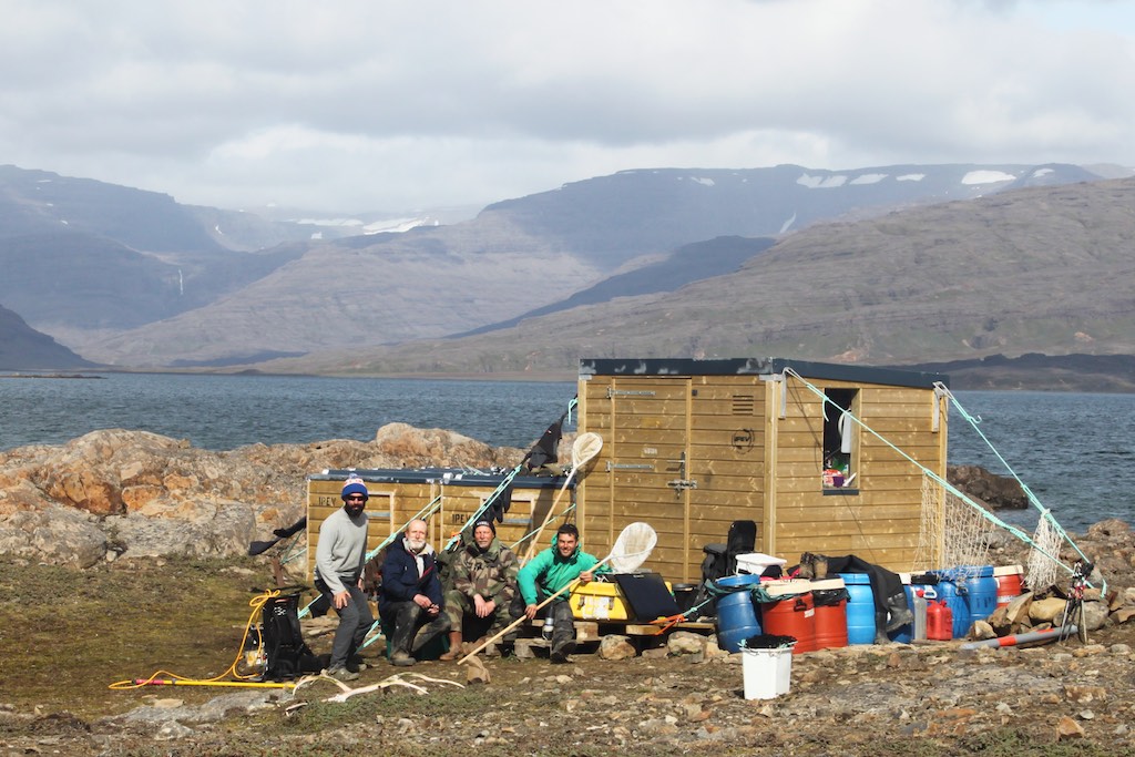
We started off our manip at 5:45 a.m. with 1.25 hour (56 km) Zodiac ride on a beautiful Kerguelen morning. It was almost a Mumbai morning. A Mumbai morning is the term I use to describe a mornings where the air is still, almost crisp, the sky is cloudless and a brilliant mix of red, orange, and pink just before the sun rises above the horizon. The only thing it missed was the sweet smell of wood fires that fill the Mumbai air when people are cooking breakfast—fires are forbidden in a French Reserve Naturelle… Anyways, we landed at Cabin Bossiers, our push off point for the 25 km hike to Val Travers, to find a tiny cabin nestled at the base of a waterfall.
I say tiny but, as we were to find out, it would be one of the larger cabins on our manip. For those at Acadia/those who have been on The DC (Coastal Ecology lab boat), the cabin was roughly the size of the lab boat. For the rest, Cabane Bossiers is a whopping 5 m long by 1.5 m wide, and 2.5 m tall . There was no place to escape the snoring of our chef de mission. When asked how he slept, Christian (our French Marine replacement maniper), replied, “I didn’t.” Jessy and myself, at this point almost completely immune to the ronflements of Philippe, only had to contend with the rain. The cabin is made of metal and condensation from our breathing caused it to ‘rain’ on the top bunks all night.
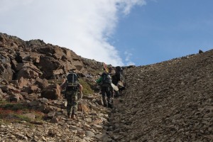
The next day we set off for Val Travers at 6:30 in the morning. The first five hours of the hike weren’t overly difficult, but we were all carrying the heaviest loads (18–25 kg) of our Kerg manips. Oh, and we had all of the weather Kerguelen has to offer—sun, wind, snow, rain, and hail. We passed a series of lakes and hiked up a river valley following a pencil line drawn on a map–a route taken by the geologues (geologists) a month or two earlier. Now, following a line on a map and figuring out how it translates to the route on the ground is a lot easier from the comfort of the lab (lesson: plateaus on the map don’t mean easy going plateaus on the ground, but hellish terrain that doesn’t change elevation enough to warrant another line on the map). The next five hours were a slog as the weight of our packs, fatigue, and rough terrain. We ended up traversing out of Vallee Bossiers too soon, choosing a steep and narrow route up the side of a mountain and then trail breaking to find a descent into Val d’Aoste, which is perpendicular to our destination of Val Travers. We slowly made our way to the head of Val d’Aoste and were rewarded for the day’s work.
The view from the ridge above Val Travers was incredible. Ancient lava flows, snow capped mountains, waterfalls, and meandering rivers were just a few of the treats we saw. It was breathtaking… literally. The wind was gusting up the slope at 50+ knots, making it hard to breathe and maintain balance. Now, I am not afraid of heights, but I am petrified of falling from them. Looking over the edge of the cliff to the valley 450-500 m below, it dawned on me, “Oh merde, we have to make it down somehow.”
The descent into Val Travers was one of the scariest parts of the trip. I won’t go into detail, for that you’ll have to entice me over a beer. I will say that several couloirs, a lot of slippery shale, and countless zig-zags later, we made it to THE Val Travers. It took an hour slog over soggy ground to finally reach the cabin and finish our 10 hour trek.
Now, I’ve talked about the lovely folks at IPEV (Institute Polaire Francaise Paul Emile Victor) before, but the times when you really appreciate their logistical support are times like this. We got to the cabin and were greeted by the amazingly stocked IPEV tuques (toilet paper/garbage bags/camping supplies/food/treats, etc.). The go-to after a long trek/hard traverse is a little drink called ‘Panache’ (a shandy)—basically carbonated lemonade mixed with draught beer that has an alcohol content of 0.5%. After a long day, the panache is a rejuvenator, a resurrector, a sugary godsend that quiets the aching joints, sore feet, and threat of dehydration and enables us to put gear away, make camp, and get squared away for an early evening—typical lights out after big treks is 8:30–9:00 p.m…
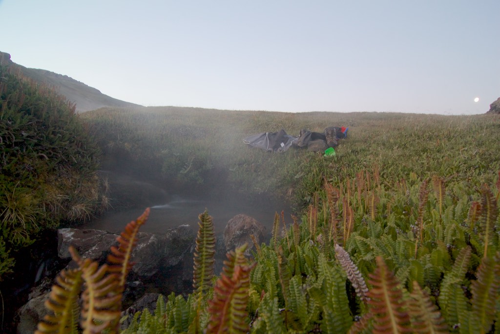
 The cabin at Val Travers is about 2 m shorter than Bossiers, has a little hole in the door where the mice like to come and go, and is quite ‘cozy’ with four men as tenants. I couldn’t imagine staying here in the winter. One of the highlights of Val Travers is the hot spring just around the corner from the cabin. After a long day of hiking and sampling (lugging the electrofisher), sliding into a hot spring is quite the experience. The meandering spring flows down the foot of a small mountain and consists of multiple pools of varying temperatures.
The pool I chose was approximately 40–60°C and was uncomfortably hot, initially. As you slowly inch your way into the 30-40 cm deep water, the freshly immersed flesh explodes in waves of screaming heat just as the bits that have been exposed for 30-45 seconds acclimatize and begin to enjoy the warmth. The stepwise immersion took a good 5-10 minutes before it was complete. While sitting in the hot spring and looking over the river valley below, I realized that the closest people on the planet (besides our team) were back on base 60 km away… pretty wild. I also had the thought that the hot spring experience, could be one of the only experiences that has not changed for humans throughout the millennia (despite the ridiculousness, no drugs or alcohol were involved—maybe the heat was getting to me?). Anyways, getting out of the hotspring you feel reinvigorated/rejuvenated/refreshed. Like you don’t need to shower for a week (by the end of our trip it was two weeks no shower). Like you just took a swim in the cold Margaree River and now you’ve got pins and needles over your entire body. The feeling lasts for about a day
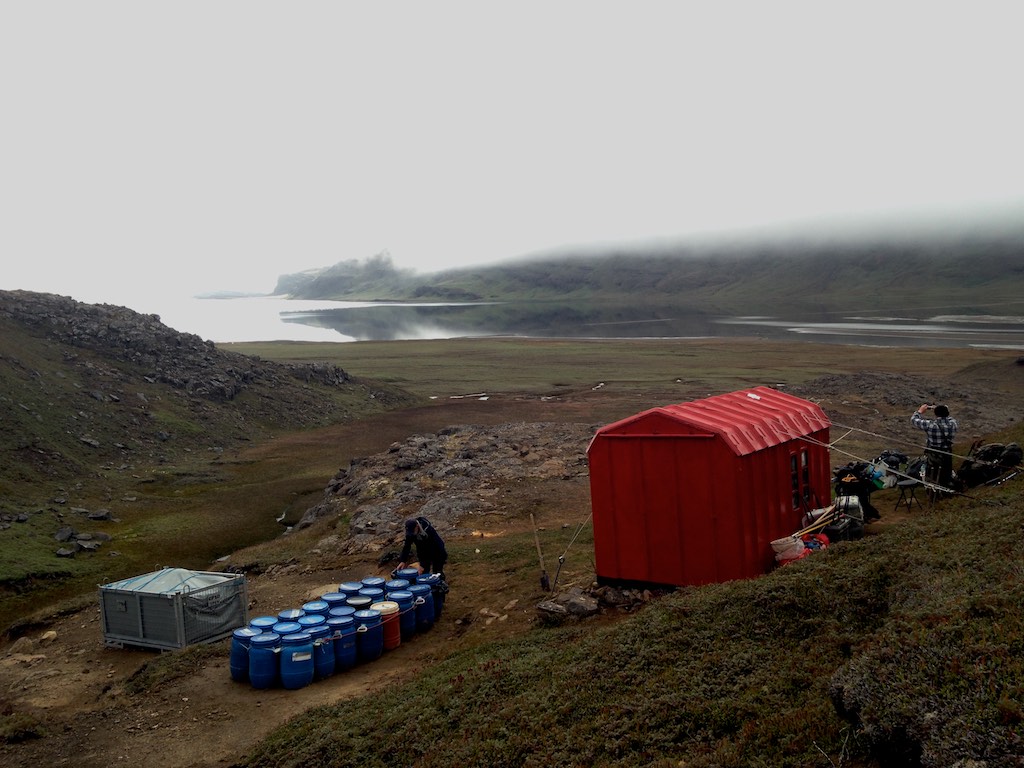
Cabane Bontemps – prep for OTN-Kerguelen 2.0
The next day we set out from Val Travers to Cabane Bontemps (even smaller than Val Travers, but with two sleeping pods) on the other side of Lac Bontemps where we started preparations for a manip next year. My part of the mission was to deploy hydroacoustic receivers and tags to test how well they work in the particular environment(s) under field conditions—a ‘range test.’ A lot of you are fish people, but some of you aren’t so I’ll try to briefly explain: basically, an acoustically tagged fish swims around with its tag pinging away in its abdominal cavity. When the fish is within range of a receiver, the receiver decodes the tag’s transmissions and registers them as detections. You receive an ID code, associated sensor data (temperature, depth, salinity, acceleration, etc.), and position (receiver’s location). A range test is used to figure out at what distances you can detect your tags and to understand how well your equipment works in the particular location (each site is different) and weather conditions (current, wind, rain, etc., reduce the detection range). Once you have this information you can design your array, with the appropriate spacing between receivers, to answer your fishy questions.
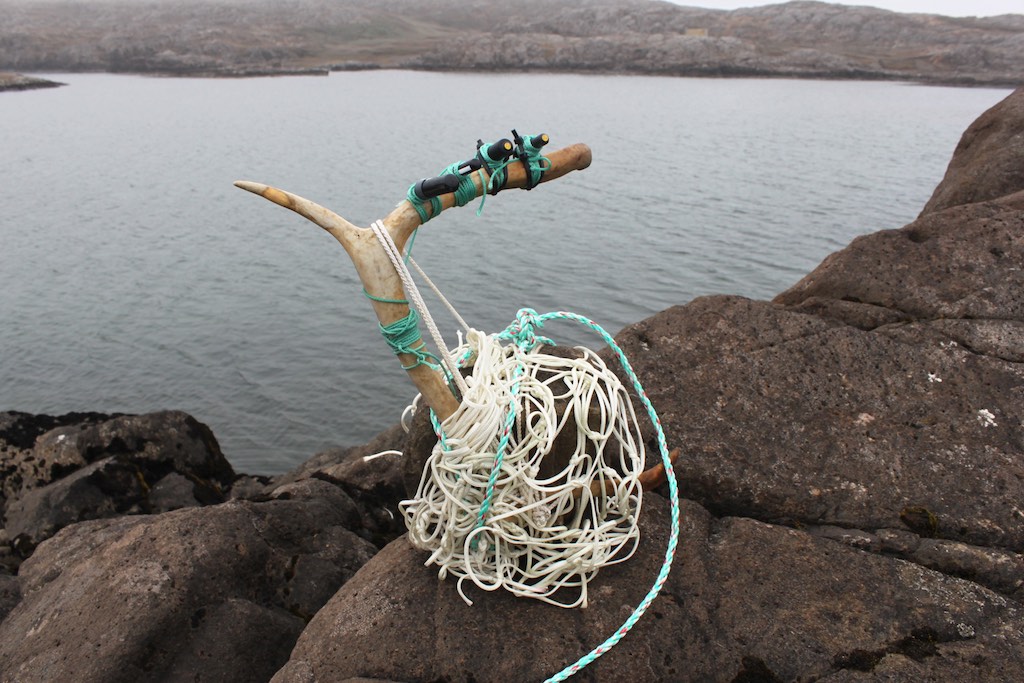
 The logistics of hiking mooring gear and receivers 30-40 km was complicated by the fact that all of the supplies I brought with me for the range test were in an unknown location in one of the infamous lost suitcases*. To complicate matters further, my whole plan for testing a series of distances was thrown for a whirl when we discovered that the glacially carved lake had very few suitable sites for receiver deployment. We ended up constructing moorings out of nets filled with rocks and a receiver mounted on top (thanks for the Arctic pictures, Dr. Spares). The tags were mounted on small reindeer antlers—after a seemingly endless trail of antlers up to this point, it took the better part of an hour to track down this pair. We overcame the lack of suitable deployment sites—the entire lake had steep drop offs not conducive to a deployment without a boat—by choosing two potential sties for future receivers and seeing if the tags were able to be detected across the channels, behind islands, etc.
* Update to the lost luggage situation. I was informed the other day that my bags have been located and are now on board the Marion Dufresne. I will have them on Kerg for 5 days before we depart on April 22nd.
Range tests were performed in Lac Bontemps, it’s estuary, and at the estuary of a glacial river, Riviere de Froide in the neighbouring Vallee des Merveilles (VM). To get to VM we were again following a line drawn on a map by thegeologues. We were told that the route was impassable and that we would have to hike four hours to get where we wanted to go. What did we do? We proceeded along the impassable route and after 45 minutes of following dead ends (i.e. arriving at the edge of a +100 m cliff), Jessy found a descent to a lower level plateau. Now, the ‘route’ was basically climbing down beside/traversing a trickle of a waterfall; the waterfall is not passable if you have rain. I don’t know if it was the 20 m drop to the next plateau below or the 17 kg awkward electrofisher on my back, but the whole fear of falling thing kicked in again (needless to say, I survived). From the cabin to the beach, we made our transit in just over two hours (two days later we found another short cut and made it in 1h45min). This was fortunate as we had to work against the clock of the rising tide to deploy six range test stations (four receivers and two tag stations).
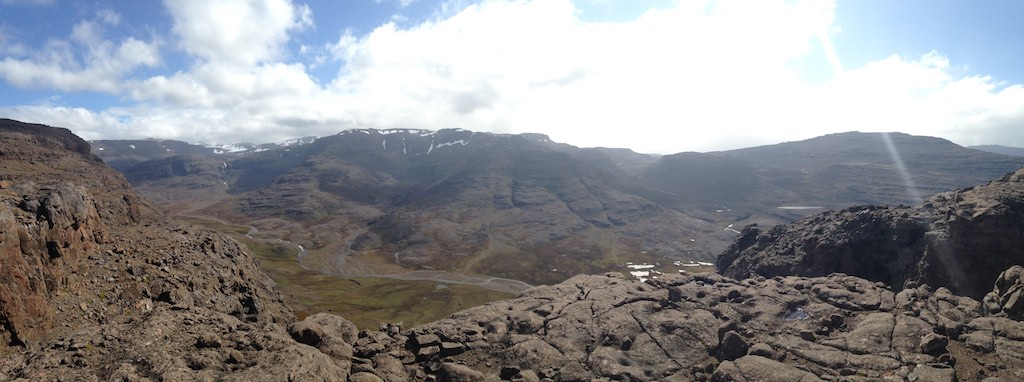
We spent the rest of the day discovering that the invasion of brown trout had spread to the Vallee des Merveilles—prior missions had not observed trout in this area. On the hike back we took the ‘over the mountain’ route home. We were treated to spectacular panoramic views of Val Travers, Lac Bontemps, Baie Irlandese, and the spectacular Cook Glacier (the largest French glacier).
I will try to wrap this up soon…
At Bontemps, we did a lot of angling and I think this is where the years of fishing in Nova Scotia estuaries paid off big time. Spending time on the water fishing (especially when you hang around fine fisher folks like Reg Madden, Jeremy Broome, and Sam Andrews) you gain an understanding of where the fish are on each part of the tide and how to catch them. We hooked fish after fish, beautiful 2-3 kg sea run brown trout. There is a lack of photos due to the constant fog, drizzle, and requirement to release the fish as quickly as possible after sampling.
 The whole time we were fishing there was one solitary Gentoo Penguin (Pygoscelis papua) that had a hate on for me. The penguin wouldn’t budge whenever the others came around, but as soon as I approached (island hopping to fishing spots) it would run away. I blame the beard (mom, please show grandpa a picture of the beard… he’ll have some words).
The time spent at the Cabane Bontemps was like being at home. Aside from living on the water and the fishing, the feel and smell were the same. The coastal fog that pushed into Baie Irlandaise brought with it the cool breeze and drizzle that you feel in Halifax, Louisbourg, or on the water in July in the Bay of Fundy. The smell was the same as the sweet sea air of Main-a-Dieu, Sheet Harbour, or even Chester–crisp, clean, and piercing. It was the only time that I’ve ever felt so close to home without physically being in Nova Scotia. If you don’t know what I mean, next time there is an onshore wind and approaching fog bank, head for the coast and give’er a whiff (sorry Marty, this won’t work for you).
At the end of our Val Travers/Lac Bontemps tour we packed the cabin with gear that will be recovered by helicopter when the ship arrives (April 18th) to resupply, drop people off, and pick us up. Our exit transit was three days total. The first day we hiked ~18-20 km to Cabane Gazelle, the same size as the main cabin at Bontemps (~ 2 m x 2 m), but was set up to sleep four. The next day we were heading to St. Malo, but traversed the coast scoping out potential sites for future receivers.
St. Malo
Now, we’d visited St. Malo a month before and found that it was amply stocked with canned goodies—most of which are expired, but the ‘who can eat the most expired food available’ game is a popular/necessary one on Kerguelen**. This in mind, we didn’t pack food from Gazelle to eat for a St. Malo supper. On our arrival we discovered that all of the cupboards were empty except for an emergency package of pasta and old instant coffee. Our attempts to forage were hindered by tide and water levels. Philippe was able to scrounge up some mussels off the rocks (see St. Malo pic), but fishing was major bust. We feasted on pasta and mussels knowing we didn’t have food for breakfast…
The next morning we boarded l’Aventure II for our final transit. Hungry and, after two weeks without a shower, extremely stinky we set off for Port-aux-Francais. As has become almost ritual, a pod of Commerson’s Dolphin (Cephalorhynchus commersonii) escorted us from the bay. A fitting end to close out a spectacular manip.
** I believe our team’s record is four years past expiration date. We had a Mont Blanc (canned chocolate dessert) that expired in 2012. This is by no means a Kerg record… people will eat a lot of crazy things when cooped up in a cabin for extended periods of time.
Next update will cover trips to Val Studer, Port Elisabeth, and Ratmanoff (our final multi-day manip).
Much Love,
Colin